Yucatán is easiest to misunderstand when its history is compressed into a slogan. It was not simply an ancient Maya world that vanished, followed by a Spanish city and then a tourist economy. It is a layered region where Maya peoples, languages, land systems, cities, colonial institutions, rebellions, export agriculture, migration and modern state politics continue to shape one another.
That long view is useful for travelers. A visit to Mérida’s Plaza Grande, a Puuc site, a former henequen hacienda or a small town church becomes more legible when you know what came before it—and what the building cannot tell you by itself. This guide follows the major periods without pretending that the boundaries were clean. Dates are approximate where archaeological or historical sources remain debated, and “Yucatán” changes meaning depending on whether we mean the peninsula, the colonial province, the nineteenth-century state or today’s Mexican state.
Quick answer: how Yucatán history fits together
| Period | What changed | What travelers can still encounter |
|---|---|---|
| Early Maya settlement and city-building | Communities adapted to limestone, seasonal rain and underground water; cities developed different political traditions. | Archaeological zones, museums, cenotes and landscapes shaped by ancient land use. |
| Classic and Postclassic Maya worlds | Powerful centres such as Uxmal, Chichén Itzá and later Mayapán rose, competed and changed. | Monumental architecture, inscriptions, sculpture and living Maya place names. |
| Spanish conquest and colonial rule | Spanish authority, Christianity, new diseases, tribute, land arrangements and towns were imposed unevenly. | Mérida’s colonial core, churches, convents, archives and mixed architectural traditions. |
| Independence and the nineteenth century | Yucatán negotiated regional autonomy, political conflict and unequal citizenship; the Caste War began in 1847. | Museums, memorials, town histories and communities shaped by the conflict. |
| Henequen export era | Agave fibre connected Yucatán to global industry while concentrating land and wealth and exploiting labour. | Haciendas, rail alignments, factory ruins, museums and restored estates. |
| Revolution and modern Yucatán | Land reform, unions, state institutions, tourism, migration and cultural revitalization reshaped the economy. | Contemporary Mérida, regional towns, Maya-language work and community tourism. |
The most important correction is that Maya history did not end with the decline of a particular city. Political centres changed, but Maya communities continued through colonial rule, nineteenth-century war and the modern period. Nor did the Spanish conquest happen in one afternoon. Campaigns, alliances, resistance, disease, negotiation and renewed rebellion unfolded over generations.
For an official state-level chronology, compare the Government of Yucatán’s historical overview with the more critical institutional and academic material linked below. For archaeology, the INAH museum and site network is the useful starting point. The state overview is valuable for dates and public reference, but like any official narrative it should be read alongside Maya-centered scholarship and evidence about land and labor.
The landscape that made Yucatán different
The peninsula is a broad limestone platform rather than a region organised around large permanent rivers. Rain sinks through porous rock, creating an underground aquifer and natural openings known as cenotes. Seasonal rainfall, thin soils, scrub forest, wetlands and coastlines forced communities to develop detailed local knowledge about water, crops, fire, forest products and movement.
This geography did not prevent urban life. It shaped it. A city’s strength depended on access to water, the ability to manage food production, relationships with surrounding settlements and control of routes or sacred places. Some sites relied on cenotes; others used reservoirs, chultunes or aguadas to collect and store rainwater. The practical and sacred meanings of water were closely connected in Maya thought, so a place with dependable water could also become a ritual and political centre.
Modern roads can make the state look empty between destinations, but ancient landscapes were not empty. Fields, household compounds, paths, gardens, forest resources and small settlements surrounded monumental cores. Archaeological zones preserve only a fraction of that settlement pattern. When you walk around a temple, imagine not an isolated ruin but a working landscape of farmers, builders, cooks, traders, craftspeople, children and ritual specialists.
The environment also explains why “Maya civilisation” cannot be treated as one centralised empire. Different cities and polities controlled different territories at different times. They shared languages, writing traditions, religious concepts and artistic conventions, but they also competed, made alliances and followed local political paths. The peninsula’s history is a history of connected but independent communities.
 The Juego de Pelota at Uxmal, a monumental Maya site in the Puuc region of Yucatán
Before the famous cities: deep Maya time
People lived in the peninsula long before the buildings most visitors recognise. Archaeologists use changing tools, ceramics, settlement traces, burials, architecture and environmental evidence to reconstruct long sequences of occupation. The dates and labels vary by region, but Maya history in Yucatán reaches back thousands of years and includes many forms of settlement that were not monumental.
Early communities domesticated and cultivated plants, hunted, fished, gathered forest products and developed increasingly complex relationships with maize. Agriculture was never simply “planting corn.” It involved reading rainfall, managing soils, combining crops, maintaining household gardens and using the forest. Maize, beans and squash formed an important combination, but food systems also included chiles, fruits, roots, animals, honey and aquatic resources.
Over time, some centres built platforms, temples, reservoirs, plazas and elite compounds. Monumental architecture required more than an ambitious ruler. It required organised labour, quarrying, transport, specialist knowledge, food surpluses and political systems capable of mobilising people. The surviving stone therefore records both creative achievement and unequal social relationships.
Maya writing provides names, dates, titles, rituals, warfare and dynastic claims, but inscriptions are not neutral newspapers. They were commissioned by rulers and placed in political settings. Archaeologists combine them with household evidence, ceramics, settlement surveys, environmental studies and comparisons among sites. A careful history distinguishes what an inscription says from the wider conclusion we draw from it.
Regional Maya powers: Uxmal, Chichén Itzá and Mayapán
The cities most familiar to visitors belong to different moments and political landscapes. Uxmal was a major centre in the Puuc region, known for elaborate mosaic façades, carefully planned plazas and architecture adapted to local traditions. Its rain imagery is particularly important in a landscape where rainfall and water storage were central concerns. The Puuc region was not a single city but a network of settlements whose relationships changed over time.
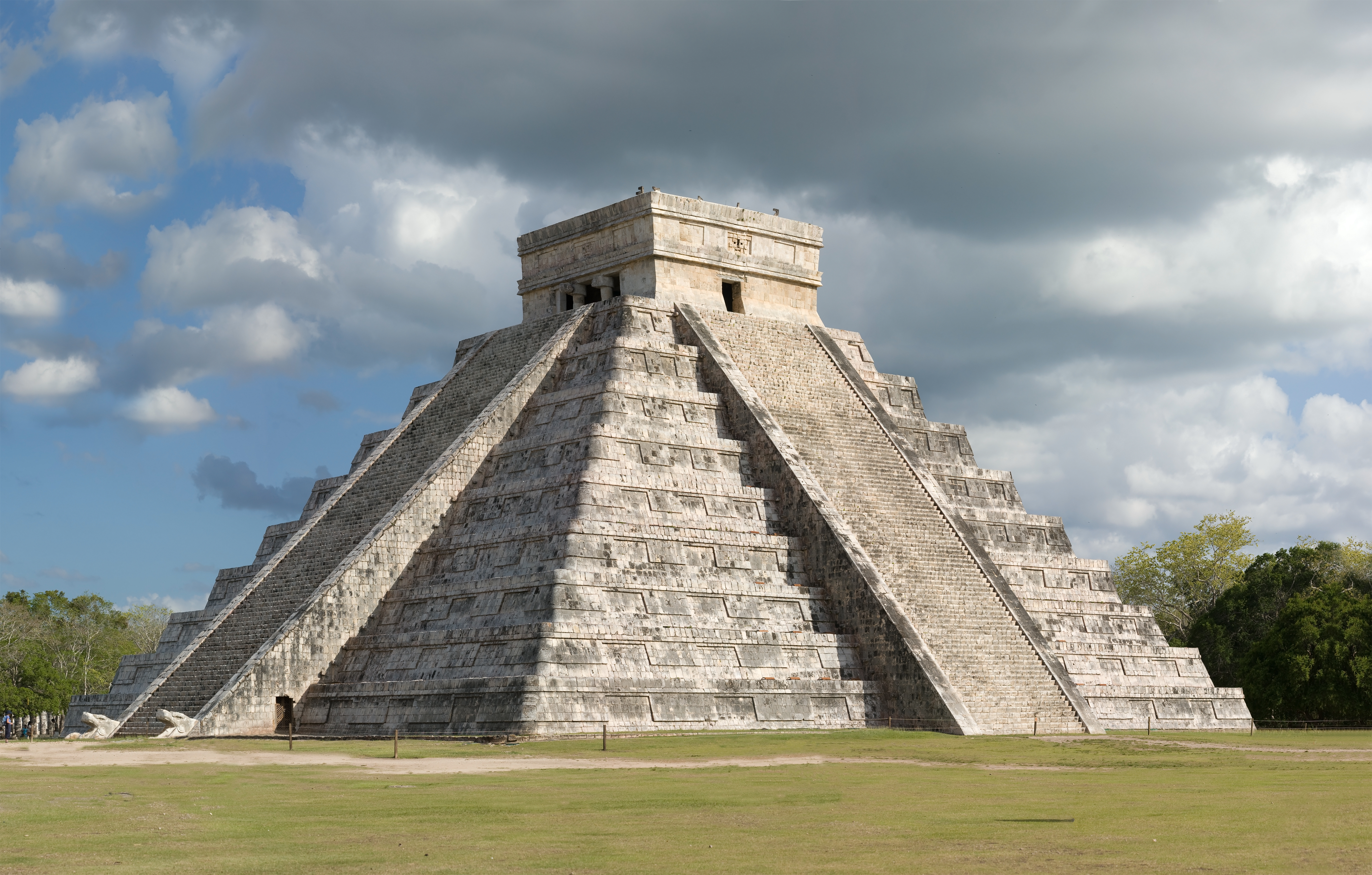
Chichén Itzá became one of the strongest centres of northern Yucatán during the Terminal Classic and early Postclassic transition. Its Great Ball Court, Temple of the Warriors, El Caracol, Sacred Cenote and Temple of Kukulcán show a city using monumental space to communicate ritual and political authority. Older accounts framed its art as evidence of a simple Toltec conquest. Current interpretations are more cautious: central Mexican connections may reflect exchange, migration, diplomacy, shared ideas, political strategy or several processes at once. INAH’s Chichén Itzá material is a useful way to continue that discussion.
Mayapán rose later as an important political centre in northern Yucatán. Colonial-era accounts describe its alliances and conflicts, but those sources were recorded after the events and contain contradictions. Archaeology presents a densely settled walled city with domestic areas, temples and political compounds. It should not be treated as merely the successor that “replaced” Chichén Itzá overnight. Centres lose influence, households move, sacred places endure and regional power is redistributed over time.
Other sites add essential context. Acanceh shows how a town close to modern Mérida preserves monumental remains within a lived landscape. Dzibilchaltún demonstrates the long occupation of a northern centre and the importance of water and seasonal solar alignments. Ek Balam reveals a different urban and artistic history east of Valladolid. The Ruta Puuc, including Kabah and smaller sites, makes comparison possible: Maya architecture was inventive, regional and historically changing, not one standard style.
When visiting ruins, avoid the word “abandoned” unless you explain what you mean. A city may stop being a dominant political centre while people continue to live nearby, visit a sacred feature or remember the place. “Decline” can describe a reduction in construction or political reach; it does not mean that a people disappeared.
GuideMayapán Ruins: Is It Open? History, Closure & Alternatives from MéridaMayapán is a compact Postclassic Maya archaeological zone located a short drive southeast of Mérida, but it is not currently open to normal public visits. The site should be treated as closed, and travelers should not plan a dedicated trip there unless they obtain same‑day confirmation from the Centro INAH Yucatán, a trusted local guide, driver, or Mérida‑based operator that access has resumed. Because the article gives no ticket price, opening hours or official schedule, none of those details can be provided. The only practical guidance is that, if the site does reopen, a visit would typically last about one to one and a half hours and would include seeing the main Temple of Kukulcán, the central plaza, the distinctive round buildings, colonnaded halls, and the surrounding wall. No specific services or amenities are listed as included. Visitors should verify the site’s status on the day of travel and, if it remains closed, redirect the day to confirmed‑open alternatives such as Uxmal, Chichén Itzá, Dzibilchaltún, Acanceh, Tecoh, or nearby cenote trips in Homún or Cuzamá. When using a driver or tour, ask them to confirm access before departure; if self‑driving, do not rely solely on map apps or outdated blogs. Should Mayapán be open, arriving early is advisable to make the most of the brief, quieter experience.Open
How to visit the archaeological history
Choose one main site and give it enough time rather than trying to collect every ruin in one hot day. Uxmal works especially well with the Puuc region; Chichén Itzá benefits from an early start and attention to its museum and separate architectural groups; Ek Balam pairs naturally with an eastern Yucatán itinerary; Mayapán requires current access checking because its operational history has changed. Compare current archaeological and cultural tours on GetYourGuide and see broader Yucatán options on Viator, but check the exact meeting point, inclusions and site schedule before booking.
The stone is only one source. Read museum labels, listen to local guides, compare the restored surfaces with less-restored areas and notice the distance between a modern site label and the evidence behind it. A good guide will say when a function is proposed rather than certain.
Colonial conquest was a long process
Spanish expeditions reached the peninsula in the early sixteenth century, but arrival was not the same as control. The Spanish encountered multiple Maya polities with their own interests and rivalries. Expeditions used violence, alliances, interpreters and Christian claims. Maya communities sometimes fought, sometimes negotiated and sometimes used Spanish rivalries for their own purposes.
The conquest of Yucatán took decades. The first encounters brought epidemic disease and new military pressures, but Spanish forces did not simply sweep across a unified kingdom. Geography, distance, limited Spanish resources and Maya resistance all shaped the process. The formal establishment of Spanish towns and institutions did not erase Maya authority in every community or end resistance.
The word “discovery” is misleading because the peninsula was already densely inhabited and politically organised. A more accurate phrase is Spanish invasion and conquest, followed by colonisation. The terminology matters: it keeps Maya people in the story as historical actors rather than treating them as scenery encountered by Europeans.
Mérida was founded in 1542 on the site of the Maya settlement of T'Hó, also written Tiho or Ichcanzihó in different sources. The Spanish city reused stone and occupied an existing landscape. Its grid, cathedral, civic buildings and churches expressed colonial power, but the city depended on Maya labour, food production, knowledge and trade. The built centre was never socially or culturally Spanish alone.
The colonial order imposed tribute, religious conversion, labour obligations and new legal categories. Encomienda and other systems extracted resources from Indigenous communities, while clergy and local officials attempted to reorganise settlement and belief. Maya communities adapted, resisted, litigated, preserved land claims where possible and maintained language and social practices under pressure.
 The historic centre of Mérida, Yucatán, showing the colonial urban layer within a living capital
Mérida’s colonial city and Maya foundations
The centre of Mérida is best read as overlapping histories. The cathedral and the Plaza Grande represent colonial institutions, yet their materials and location are connected to the earlier Maya settlement. Streets, churches, convents, government buildings and private houses changed repeatedly. A colonial façade may hide later repairs; a modern use may occupy a building with several political lives.
The cathedral was built over decades and became a major symbol of ecclesiastical and civic authority. Nearby government buildings turned the plaza into a stage for administration, ceremony and public power. That arrangement was not accidental. Spanish urbanism used the central square to make hierarchy visible: church, government, commerce and residence were placed in relation to one another.
Yet colonial life outside elite buildings was not simply a copy of Spain. Maya workers built and maintained the city. Indigenous communities supplied food and labour. African and Afro-descended people were also part of colonial Yucatán, though their histories are often less visible in tourist narratives. Spaniards, criollos, mestizos, Maya and others occupied unequal legal and economic positions that changed over time.
Religious life developed through confrontation and adaptation. Missionaries condemned Maya ceremonies, sacred places and objects, while Maya communities incorporated Catholic institutions into local social worlds. Churches and festivals can therefore carry multiple histories at once. It is inaccurate to label every contemporary practice either “purely ancient” or “purely Spanish.”
A visitor can explore this layer through Mérida’s centre, the Ruta de los Conventos, Izamal, Valladolid and smaller towns. The Mérida museums guide is a useful companion when you want collections and exhibitions rather than only street architecture. For a base in the capital, check current Mérida stays on Booking.com and compare Mérida hotels on Trip.com; central walkability is convenient, but verify the exact location, parking and air-conditioning details.
Independence did not end colonial inequalities
Mexico’s independence movement transformed legal sovereignty but did not automatically create equal land access or social power. Yucatán became part of an independent Mexico while regional elites, municipalities and Indigenous communities negotiated authority. Political conflict between centralist and federalist forces, and between Mérida and Campeche interests, added another layer to the nineteenth century.
Liberal reforms often promised equal citizenship while weakening communal land protections or making land easier to privatise. The practical consequences were severe when commercial agriculture expanded. Laws and court systems that looked universal on paper could operate very differently for communities with fewer resources, limited access to legal representation or official documents.
The nineteenth century was not a simple struggle between two fixed races. “Caste” was a colonial and political language used to describe hierarchy, and scholars debate how best to name the later conflict. Class, ethnicity, land, debt, taxation, religion, regional politics and military recruitment all mattered. Using the conventional name Caste War is unavoidable, but it should not hide the war’s material causes or turn Maya communities into a single undifferentiated side.
The Caste War of Yucatán
The conflict began in 1847 in a region already shaped by colonial exploitation, post-independence political instability, land pressure and unequal taxation. Maya communities had different interests and leaders. Some participated in the rebellion; others allied with government forces or defended local positions. The war spread across much of the peninsula and became one of the most consequential Indigenous rebellions in nineteenth-century Mexico.
The first phase brought rapid rebel advances and the flight of many non-Maya residents from eastern and southern areas. Government forces responded with military campaigns, reprisals and attempts to recover territory. The conflict was not brief, and neither side exercised uniform control across the peninsula. Food production, disease, migration and the planting cycle affected the course of war as much as battlefield victories.
In the east, the movement developed religious and political institutions around the Speaking Cross, or Cruz Parlante. The community associated with Santa Cruz maintained autonomy for decades and later gave its name to the territory that became central to the history of Quintana Roo. The movement should not be described merely as superstition. It combined spiritual authority, political organisation, social discipline and resistance to outside rule.
The government of Yucatán also took brutal measures. Maya captives were sold or transported to Cuba, a fact that official celebratory histories may minimise but that must be included in an honest account. The war caused enormous death, displacement and economic destruction. Estimates vary depending on the period and categories counted; use broad descriptions rather than repeating a single dramatic number as settled fact.
The conflict formally continued into the twentieth century. Mexican forces occupied Chan Santa Cruz in 1901, but resistance and separate political realities did not end instantly. The eventual incorporation of the eastern territory into stronger federal administration was tied to the creation of Quintana Roo in 1902 and the changing strategic interests of the Mexican state.
The Caste War changed Yucatán’s geography. It devastated parts of the southeast, moved population and political weight toward the northwest and contributed to the conditions under which the henequen economy expanded. But it is wrong to say that the war was simply a prelude to plantation prosperity. The relationship involved violence, land seizure, labour exploitation and the destruction of communities as well as export wealth.
For a concise institutional discussion, read the INAH account of the Maya rebellion and the UNC Libraries exhibition on the Caste War. They do not replace specialist books, but they help correct the familiar tourist version in which the conflict appears suddenly and ends neatly.
How to encounter this history respectfully
Many travelers encounter the Caste War indirectly: in a museum label, a town history, a church, a former military building, a family story or a place name. Do not ask a Maya person to perform the war for you or to explain “what the Maya think” as if every community shares one view. Ask guides how they identify their sources, and allow room for disagreement.
When visiting a community festival or cemetery, follow local rules. A public event is not automatically a photo set. Ask before photographing people, altars, ceremonies or craftwork. Buy directly when possible, pay fairly and do not treat bargaining as entertainment. The history of extraction is not separate from the way visitors spend money today.
Henequen: the plant behind the “green gold”
Henequen is a cultivated agave whose strong fibre became valuable for cordage and especially for industrial binder twine. The plant had older local uses, but global demand transformed its economic importance in the nineteenth and early twentieth centuries. Yucatán’s dry soils and established agricultural knowledge made large-scale production possible, while railways and ports connected plantations to international markets.
The export boom concentrated wealth among owners, merchants, financiers and political families. Henequen estates controlled land, processing equipment, transport and worker housing. The polished hacienda house was only one part of the system. Fields, desfibradoras, workshops, wells, rail sidings, stores and labour arrangements made the plantation function.
Maya workers formed the core of the workforce, and their labour was often controlled through debt, advances, coercion and restricted mobility. The exact organisation varied among estates and periods, but the idea of a romantic hacienda should never erase the people who planted, cut, carried, scraped, dried and packed the fibre. Export prosperity rested on unequal land and labour relations.
The henequen economy also changed food and land use. As plantations expanded, land that had supported subsistence crops or communal use was redirected toward a cash export. Global price changes, drought, war, technological change and labour politics affected the industry. The boom generated modern infrastructure and spectacular private fortunes, but its benefits were not distributed equally.
 Henequen drying racks in the southern Yucatán, a reminder of the industrial work behind the hacienda landscape
Haciendas, railways and what the ruins mean now
Today, haciendas are among Yucatán’s most photogenic historical places. Some are hotels, restaurants, event venues or museums; others are private, partially ruined or still connected to rural production. Their architecture—arcades, courtyards, machinery rooms, gardens and grand houses—can be beautiful, but beauty is not the same as innocence.
A responsible visit asks two questions at once: what survives physically, and whose labour made it possible? Look for information about the estate’s workers, the processing system, land ownership and the transition after the boom. If interpretation only celebrates an owner’s house, it is incomplete.
The rail network connected plantations to Mérida, Progreso and regional towns. Some lines have disappeared, while road corridors and town layouts preserve traces of their importance. The port of Progreso was crucial to export movement, but Mérida remained the state’s inland political and commercial centre. Do not describe Mérida as coastal or give it a malecón; coastal infrastructure belongs to places such as Progreso, Sisal and Celestún.
Several haciendas are now bookable cultural visits or overnight stays. Compare current hacienda and heritage tours from Mérida on GetYourGuide and see Viator’s Mérida and Yucatán activity inventory. If you decide to stay in a restored estate, verify the property’s current status and location through Booking.com’s Yucatán accommodation inventory and Trip.com’s Yucatán hotel listings. A restored room is not a time machine; it is a modern business operating in a historical building.
Revolution, land reform and the end of the export order
The Mexican Revolution reached Yucatán through conflict over labour, land, political authority and the henequen economy. Salvador Alvarado’s governorship from 1915 to 1918 is often remembered for reforms affecting education, labour, women’s organisations and the political order. His administration also confronted the power of henequen elites. The period was transformative but not free of coercion or contradiction.
Land reform and changing labour law weakened the old estate system over time. Workers organised, state institutions expanded and the global market for henequen became less secure. Synthetic fibres eventually reduced demand for natural cordage, while international competition and changing industrial methods undermined Yucatán’s dominant position.
The end was gradual rather than one dramatic collapse. Some estates adapted, some were divided, some were abandoned and others found new uses. State-backed industrial projects attempted to reorganise production, including the creation of Cordemex in the 1960s. The social consequences—migration, changed employment, altered rural communities and debates over land—continued long after the export boom ended.
This transition explains why a hacienda can feel both grand and empty, and why a regional town may have a centre shaped by nineteenth-century wealth but a present economy based on education, services, agriculture, tourism or migration. History is not preserved only in monuments; it is also visible in what the old system stopped providing.
Yucatán in the modern period
Modern Yucatán is a Mexican state with Mérida as its capital, but its identity is regional and layered. Spanish is widely used, while Yucatec Maya—Maayat'aan—is spoken by many people and remains central to family, community and cultural life. Urbanisation, education, migration, tourism, media and economic change have altered language use without making Maya culture a relic.
Mérida expanded beyond the historic centre, and new neighbourhoods, universities, hospitals, industries and cultural institutions changed the city’s role. The capital draws people from rural Yucatán and from elsewhere in Mexico and the world. Its contemporary culture cannot be reduced to colonial façades, just as rural life cannot be reduced to an “authentic” postcard.
The state’s coastal economy, inland towns, archaeological sites, agriculture and service sector are connected but different. Progreso functions as a port and beach destination; Celestún and Río Lagartos are shaped by wetlands, fishing and protected-area tourism; Valladolid sits within an eastern route of cenotes, archaeology and colonial history; the Puuc south has its own terrain and town networks. Travel between them is also travel across different histories.
Maya cultural revitalisation is visible in language work, foodways, crafts, community tourism, research, art and public debate. It is not a museum reconstruction. Younger Maya people may combine local knowledge with university study, smartphones, wage work, migration and entrepreneurship. Visitors should avoid the idea that a tradition becomes less meaningful when it changes.
 Maya agricultural imagery in Yaxcabá, connecting contemporary Yucatán with land, food and community memory
Museums and places that make the timeline clearer
A history route works best when it mixes major monuments with museums and ordinary town landscapes. In Mérida, the regional anthropology museum, the city’s historic centre and specialist exhibitions can establish the colonial, archaeological and modern layers. Check current hours and exhibitions directly because museum schedules and content change.
In the interior, combine one archaeological zone with the town around it. Valladolid’s churches, streets and regional museums belong to a living city, not only a backdrop for Chichén Itzá. Izamal shows how Maya, colonial and contemporary identities occupy the same urban landscape. The Ruta de los Conventos connects religious architecture with community history, though a route is more than a checklist of façades.
Haciendas and henequen museums are useful when they explain processing, land and labour rather than presenting only a polished owner’s residence. Ask whether machinery is original, restored or reconstructed, and whether worker histories are included. A smaller museum with local testimony may teach more than a grand room filled with generic colonial furniture.
The best sequence depends on your trip. From Mérida, a city museum day can prepare you for Uxmal or a convent route. From Valladolid, an eastern archaeology day can be balanced with town history rather than another distant ruin. If you have a rental car, do not fill every hour: heat, roads, opening windows and the slow work of looking all matter. If you prefer not to drive, compare current Mérida cultural day trips on GetYourGuide and Viator’s Yucatán sightseeing options, checking whether the itinerary leaves enough time at each stop.
Common historical mistakes to avoid
“The Maya disappeared”
Ancient political systems changed, but Maya people, languages and communities continued. The modern Maya are not a vanished civilisation’s leftover descendants; they are contemporary peoples with their own identities, decisions and disagreements.
“The Spanish conquered Yucatán in one event”
Campaigns and colonisation unfolded over decades and met sustained resistance. Spanish rule was powerful but never culturally complete.
“The Caste War was just a race war”
Ethnicity mattered, but land, labour, debt, taxes, political rivalry, religion and regional power were also central. Use the conventional name with explanation rather than a simplistic binary.
“Henequen wealth was shared prosperity”
The export economy built infrastructure and fortunes while relying on deeply unequal land and labour systems. A hacienda visit should hold both facts together.
“Every Maya tradition is ancient and unchanged”
Living cultures adapt. Contemporary Maya life includes old knowledge, new technologies, migration, education, wage work, political organising and creative change.
“A beautiful building tells the whole story”
Architecture reveals power and skill but can hide workers, women, Indigenous communities, Afro-descended people, conflict and maintenance. Ask who built it, who paid for it and who was excluded.
Planning a history-focused Yucatán trip
For a first trip, Mérida is the strongest interpretive base because it combines museums, colonial streets, food, public history and access to several routes. Add Uxmal or another Puuc site if ancient architecture is your priority. Add Valladolid when you want eastern archaeology, cenotes and a different urban scale. Add a coastal stop only when you want wetlands, fishing or beaches; coastal Yucatán is part of the state’s history, but it is not interchangeable with inland Mérida.
A three- or four-day plan should choose a theme rather than attempt the entire timeline. One sensible pattern is Mérida’s centre and museum, a separate day for Uxmal and the Puuc, and an eastern or convent-route day. A longer trip can add Valladolid, Ek Balam, a henequen estate or a coastal reserve. Leave one flexible half-day for weather, fatigue and a place that deserves more time.
Transport changes the history you can encounter. A rental car offers access to smaller towns and dispersed haciendas but requires careful navigation, daylight planning and a willingness to drive between sites. Buses work well on major corridors but are less flexible for rural archaeology. Private drivers and organised tours simplify logistics; compare the exact route rather than assuming a “Maya experience” includes the places you want.
Heat is a historical-planning issue as much as a comfort issue. Monumental sites are exposed, and walking distances are easy to underestimate. Start early, carry water according to site rules, use sun protection and do not plan three major open-air sites in one afternoon. The slower schedule is usually the more informed one because you have enough attention to notice layout, materials and interpretation.
Frequently asked questions
Was Yucatán always one political unit?
No. The peninsula contained many Maya polities, and the meaning of “Yucatán” changed under Spanish colonial administration, Mexican independence, nineteenth-century state politics and the later division of the peninsula into Mexican states and Belizean territory.
What is the oldest archaeological site to visit?
There is no single answer without defining “oldest,” because occupation, construction and public access are different questions. Yucatán’s archaeology includes very early settlement as well as later monumental cities. Ask a site museum or INAH source about the chronology of the particular place you plan to visit rather than treating one famous ruin as the beginning of everything.
Did Maya people build Mérida?
Maya labour and knowledge were essential to the construction and survival of colonial Mérida, which the Spanish founded on the site of an earlier Maya settlement. Saying only that “the Spanish built Mérida” hides that unequal and essential labour relationship.
Can I see henequen history without staying in a hacienda hotel?
Yes. Museums, town histories, public collections, former processing areas and day visits can all explain the industry. An overnight stay is optional and should not be treated as the only authentic way to encounter the subject.
Is the Caste War over?
The armed conflict is a historical event, but its consequences—land, identity, inequality, political memory and the relationship between Maya communities and the Mexican state—remain relevant. Avoid asking whether the war is simply “finished” as though history stopped in 1901.
How should I talk about Maya culture while traveling?
Use “Maya” for people and culture, and avoid language suggesting that Maya people disappeared. Ask permission before photographing people or ceremonies, pay fairly for local work and learn from community-defined experiences rather than seeking private life as a tourist spectacle.
A useful way to remember Yucatán history
Think in layers rather than eras that replace one another. Ancient cities were built in a living landscape; colonial Mérida occupied an older Maya settlement; independence altered legal structures without ending inequality; the Caste War reshaped the peninsula; henequen connected local labour to global industry; revolution and land reform changed the rural order; and contemporary Maya communities continue to create culture in a modern state.
That approach improves a visit. At a ruin, look beyond the famous temple to water, households and regional connections. In Mérida, notice both colonial design and Maya labour. At a hacienda, ask who worked the fields and machinery. In a town or community, remember that people are not exhibits. Yucatán’s history is worth learning because it is not finished, and because the most important stories are often still being lived.
If you build your route around one archaeological site, one museum or town, and one landscape shaped by work—rather than trying to collect every landmark—you will leave with a more accurate and generous understanding of the state.