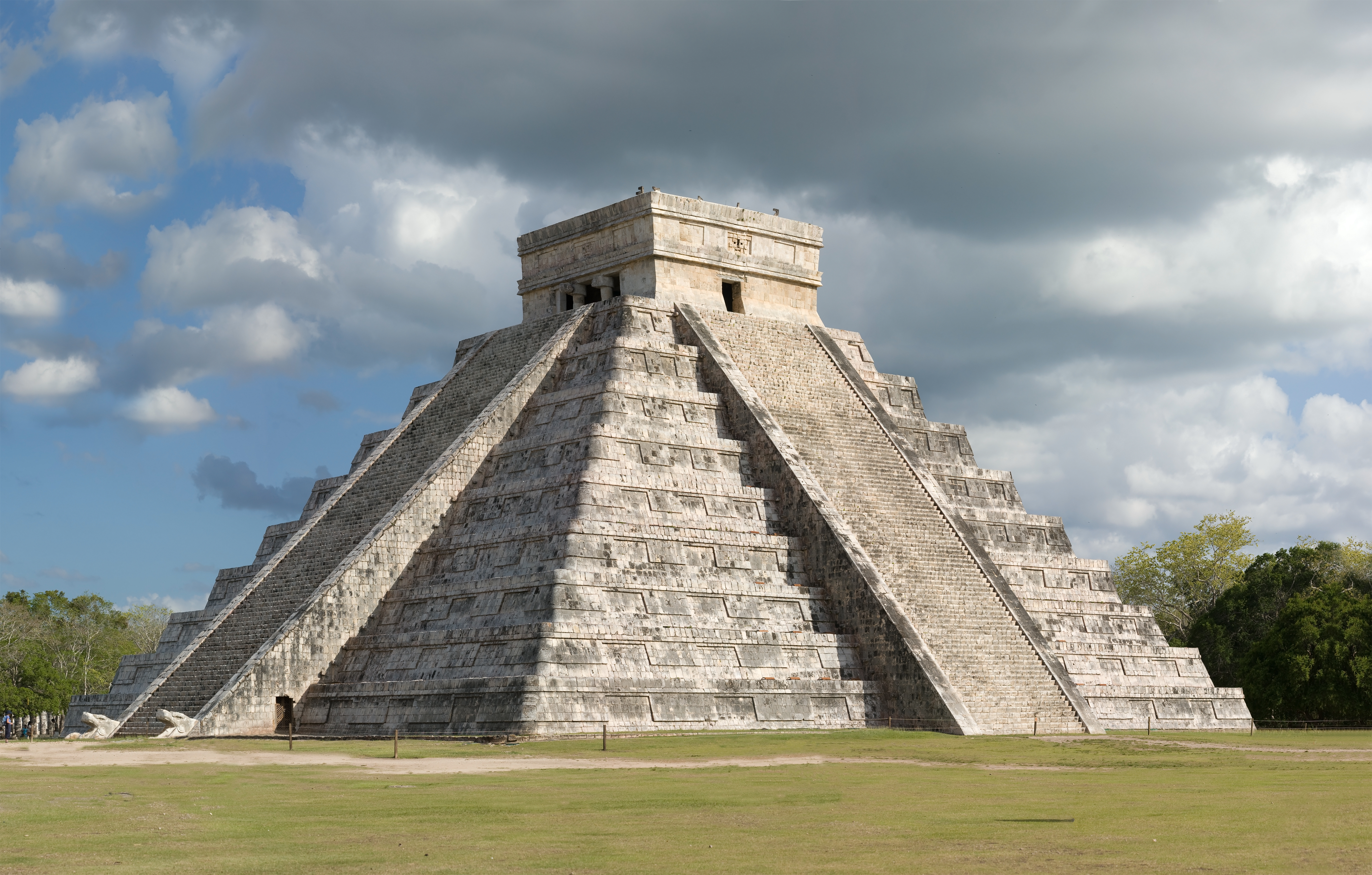
Chichén Itzá is often introduced through one image: El Castillo, the stepped pyramid standing in the middle of a broad plaza. That view is memorable, but it can also make the city seem simpler than it was. Chichén Itzá was not a single-period monument, a vanished “empire,” or a Maya city suddenly occupied by outsiders. It was a long-lived urban and ceremonial centre whose architecture, politics, trade, religion, and population changed over many centuries.
The most useful way to understand the site is as a history of layers. Early communities settled around dependable underground water. Later builders created monumental architecture in traditions shared across the northern Maya lowlands. During its most powerful centuries, Chichén Itzá connected regional politics, long-distance exchange, ritual authority, and military imagery. Its artists combined older Maya conventions with forms and ideas that travelled through Mesoamerica. After its political dominance weakened, the place remained sacred. Centuries later, archaeology, restoration, tourism, and Maya cultural continuity added further layers to the story.
This guide is for travellers who want more than a list of buildings. It explains what historians can say with confidence, where the evidence is incomplete, why the old “Maya versus Toltec invasion” story is too neat, and how to read the ruins when you walk through them.
Quick answer: what happened at Chichén Itzá?
Chichén Itzá began as a settlement in the northern Yucatán lowlands, near natural cavities that supplied underground water. The earliest dates are debated, but occupation and construction developed over a long period rather than beginning on one universally agreed foundation date. The southern sector, often described as Chichén Viejo, contains buildings associated with earlier Maya architectural traditions, including forms connected with the Puuc region.
By the end of the Classic period and into the Terminal Classic, Chichén Itzá became one of the most important centres in northern Yucatán. Its strongest monumental phase is commonly placed around the ninth to eleventh centuries, although different buildings and areas have different histories. The city’s art and architecture show deep Maya foundations alongside influences and connections associated with central Mexico and other parts of Mesoamerica.
After the thirteenth century, major new construction appears to have diminished and Chichén Itzá ceased to function as the dominant political centre it had been. The city was not simply erased overnight. Its sacred reputation, especially around the Cenote Sagrado, continued after its political decline. UNESCO describes a rapid decline after about 1440, while archaeological interpretation continues to refine the chronology and causes.
The safest summary is this: Chichén Itzá rose through water access, agricultural capacity, regional connections, political competition, ritual authority, and the ability to organise large-scale construction. It declined through a combination of changing power relationships and wider environmental, economic, and political pressures. No single dramatic explanation accounts for the whole history.
For the official international overview, read UNESCO’s World Heritage description of the Pre-Hispanic City of Chichén-Itzá. For a museum-based introduction to the city’s chronology and recent archaeological work, see INAH’s overview of the Gran Museo de Chichén Itzá.
The landscape before the monuments
Chichén Itzá is inland, in the limestone landscape of northern Yucatán. The peninsula has no river system comparable to the large rivers of other ancient civilisations. Rainwater filters through porous rock, and underground water becomes accessible through cenotes and other natural openings. That geology shaped settlement, farming, movement, ritual, and political power.
The name Chichén Itzá is commonly translated in relation to the mouth or edge of the well of the Itzá. Translation and etymology can be complicated, and the meaning should not be treated as a complete explanation of the city. Still, the association with wells and the Itzá people points toward an important reality: water was both practical and sacred.
Two natural features were especially significant. The Xtoloc cenote lies near the built-up area and helped support everyday settlement. The larger Sacred Cenote, north of the main ceremonial group, became associated with offerings and pilgrimage. A city’s access to water mattered materially, but cenotes also belonged to a Maya sacred geography in which caves, sinkholes, springs, and underground spaces could connect the visible world with other realms.
The location was not a green river valley. It was a karst environment requiring careful knowledge of rain, soil, seasonal cycles, storage, and underground water. The city’s eventual scale therefore reflects more than royal ambition. It reflects the ability of communities and political authorities to organise food production, labour, building stone, craft production, trade, and ritual around a difficult but workable landscape.
Early settlement did not necessarily look like the monumental city familiar to visitors. People would have lived in perishable structures that leave a lighter archaeological trace than temples and platforms. The later ceremonial core can obscure the long history of households, workshops, farmers, porters, traders, and other people whose work made monumental life possible.
Early Chichén and the southern city
The city’s earliest chronology is not a simple line. Colonial-era accounts, archaeological excavation, ceramics, architecture, inscriptions, and later interpretation do not always produce identical dates. Some traditional accounts place an early foundation in the fifth century, while archaeological discussion often emphasises a long sequence of occupation and construction extending across the first millennium CE.
The southern portion of the site contains buildings often associated with earlier phases. Visitors may hear this area described as Chichén Viejo, or Old Chichén. It includes architectural forms that connect the city with broader Maya traditions of the northern lowlands and the Puuc region. The name “Old Chichén” is useful for orientation, but it should not imply a perfectly separate city that was abandoned and replaced in one clean event.
Buildings in the southern group include the structure commonly called the Nunnery, the Church, Akab Dzib, and other complexes. Their decoration and masonry help researchers compare Chichén Itzá with sites farther west and south. Repeated masks of rain deities, mosaic stonework, corbelled vaults, platforms, and inscribed monuments show that the city participated in established Maya visual and architectural conversations.
The contrast between the southern and northern groups is one of the best ways to see historical change. The southern buildings can feel more intimate and varied, with dense decoration and forms associated with earlier regional traditions. The northern monumental group is more expansive in its plazas and more overtly dominated by warrior, procession, sacrifice, astronomy, and rulership imagery.
That contrast does not mean the earlier Maya tradition disappeared. Later Chichén Itzá builders reused, transformed, and combined older forms. Cultural change rarely works like a replacement of one population by another. It is more useful to imagine people adopting, adapting, arguing over, and reinterpreting styles and beliefs as relationships shifted across the peninsula.
How Chichén Itzá became powerful
Chichén Itzá rose to regional importance at a moment when the political landscape of the Maya lowlands was changing. Several major centres in the southern lowlands experienced decline or fragmentation, while northern centres gained influence. The reasons were different from place to place, and “the Maya collapse” is not a good description of every region. Maya civilisation did not vanish; political systems changed, populations moved, and new centres emerged.
Chichén Itzá’s position gave it several advantages. It had access to underground water, a substantial surrounding agricultural zone, and connections toward the north coast and inland routes. Its monumental core could host ceremonies that drew people into a shared political and religious order. Its rulers could use architecture, public performance, military imagery, and controlled exchange to make authority visible.
Power in the ancient Maya world was not only a matter of territory marked on a modern map. It involved relationships among rulers, noble families, communities, craft specialists, religious authorities, merchants, and subject or allied groups. A centre could influence distant settlements through alliances, warfare, tribute, marriage, ritual prestige, and access to valuable goods without resembling a modern nation-state.
Archaeological evidence suggests that Chichén Itzá was connected to extensive exchange networks. Items and stylistic comparisons point to contacts beyond the immediate area, including parts of the Gulf coast, the Caribbean sphere, Central America, and central Mexico. Trade did not automatically mean political control, but it increased the city’s opportunities to accumulate wealth, prestige goods, information, and relationships.
The city’s monumental architecture also functioned as political communication. A broad plaza, a raised temple, a procession of columns, or a wall of carved warriors could tell visitors who controlled the centre and what values that authority claimed. The scale of the buildings required planning and labour. The finished result made that organisational capacity visible to everyone who entered the public spaces.
 The Great Ball Court at Chichén Itzá, where architecture and carved imagery communicate public ritual and political power
Maya and “Toltec” influence: why the old story changed
Chichén Itzá’s art includes elements that earlier scholars described as Toltec. These include warrior figures, feathered serpents, Chac Mool sculptures, serpent columns, skull imagery, and architectural arrangements that have parallels in central Mexico. For much of the twentieth century, a popular explanation imagined Toltec invaders arriving from Tula, conquering the Maya, and imposing a foreign culture on the city.
That story is now treated with caution. The presence of related artistic forms does not prove a straightforward military invasion by a single group. Similar symbols could travel through trade, pilgrimage, dynastic relationships, migration, shared religious ideas, or the movement of specialists. Local rulers could also deliberately adopt powerful foreign-looking imagery to position themselves within a wider Mesoamerican world.
INAH’s discussion of Chichén Itzá and the so-called Toltec elements emphasises that the evidence supports more complex interpretations. Maya societies were not passive recipients of an outside culture. They had long histories of warfare, diplomacy, migration, innovation, and regional exchange. The “Maya-Toltec” label used by UNESCO is helpful as a description of a visible cultural fusion, but it should not be mistaken for a settled story about one invasion.
The word “Toltec” itself is also complicated. Later Nahua and Spanish sources attached prestige and ancestral meaning to Tula and Toltec identity. Ancient artists and rulers may have been invoking a broad set of ideas about sacred rulership, military legitimacy, or connections with distant centres rather than documenting an ethnic census.
When you visit, look for combination rather than division. The feathered serpent known at Chichén Itzá as Kukulcán belongs within Maya religious and political thought, while its visual presentation has parallels farther west. The Great Ball Court uses imagery that is recognisably part of a wider Mesoamerican ballgame tradition, but the exact local meanings were shaped at Chichén Itzá. The result is not a half-Maya, half-Toltec city. It is a Maya city participating in changing Mesoamerican networks.
El Castillo and the language of rulership
El Castillo, or the Temple of Kukulcán, is the building most people associate with Chichén Itzá. Its four stairways, terraces, summit temple, and carefully ordered geometry make it an obvious landmark. It is also a building where architecture, calendrical ideas, solar observation, ritual movement, and political display come together.
The pyramid should not be reduced to a calculator made of stone. The famous relationship between the structure’s geometry and the 365-day solar year is part of why modern visitors see it as an astronomical achievement, but the building’s meaning was broader. It created a stage for ritual and authority. Its elevated position made rulers and ceremonies visible. Its serpent imagery connected the human political order with divine and cosmic forces.
The light-and-shadow effect associated with the equinox is a modern visitor experience built around a real relationship between the sun’s seasonal position, the pyramid’s architecture, and the balustrade serpent heads. It should not be presented as proof that ancient builders intended exactly the same event as today’s public spectacle. The site’s relationship with the sun and calendar was embedded in a larger ceremonial system.
There is also a smaller earlier structure inside the visible pyramid. This substructure, sometimes called the Old Temple, reminds visitors that El Castillo was built in stages and that monumental renewal could preserve earlier sacred architecture. Maya buildings were sometimes enlarged, encased, and transformed rather than demolished. A political centre could make continuity visible by building over its own past.
The history of El Castillo therefore includes both construction and interpretation. Ancient builders created a powerful monument. Archaeologists excavated, stabilised, and explained it. Modern visitors attach their own expectations to it. A responsible visit keeps those layers separate while allowing the building to remain impressive.
For a focused explanation of the pyramid’s architecture and symbolism, continue to the El Castillo at Chichén Itzá guide.
GuideEl Castillo at Chichén Itzá: Temple of Kukulcán ExplainedUnderstand El Castillo at Chichén Itzá: its design, Kukulcán symbolism, astronomical alignments, history, photography, and how to visit respectfully.Open
The Great Ball Court and public spectacle
The Great Ball Court is one of the largest known courts in Mesoamerica. Its long parallel walls create a strong visual corridor, and carved panels include players, ritual imagery, vegetation, skulls, and scenes associated with sacrifice. The court was not simply a sports facility in the modern sense.
The ballgame could involve skill, competition, diplomacy, ritual, and political theatre. Different regions and periods used different rules and meanings, so it is dangerous to claim one universal explanation. At Chichén Itzá, the court’s size and placement show that the game was important enough to occupy a monumental setting near the city’s principal architecture.
The famous carved scene of a decapitated player has encouraged simplified statements that the losing team was always sacrificed. The evidence does not support such a neat rule. Sacrifice, captives, death, regeneration, and political victory appear in Mesoamerican art, but the exact identity and fate of the figures are matters for careful interpretation. The scene may connect sacrifice with the game’s ritual symbolism without documenting a standard post-match penalty.
The court’s acoustics are another reminder that architecture shaped experience. Voices and sounds can travel along the walls, although modern descriptions often exaggerate the effect. Imagine the court as a managed public environment: crowds, processions, carved narratives, officials, players, and spectators all contributed to a political performance.
 The Temple of the Warriors at Chichén Itzá, a northern-group monument surrounded by columns and martial imagery
The Temple of the Warriors and the Thousand Columns
The Temple of the Warriors stands beside a broad colonnaded complex often called the Thousand Columns. The name is traditional rather than a literal count, but it captures the scale of the space. Columns once supported roofs or defined covered and open areas used for movement, gathering, administration, ritual, or elite activity.
The temple’s façade and associated sculpture place warriors, rulers, processions, and sacred beings into the visual language of the city. Rows of columns can make a person feel small, but that was part of the point. Monumental space organised bodies. It guided where people stood, what they saw, and how they encountered authority.
A Chac Mool figure appears at the top of the temple. These reclining sculptures are associated with offerings, although their exact function and meaning varied. Serpent columns and warrior imagery create links with other parts of Mesoamerica, yet the arrangement remains specific to Chichén Itzá.
The complex also helps explain why “palace” is sometimes a misleading translation for Maya monumental buildings. Modern categories such as temple, palace, market, or government office do not always map neatly onto ancient spaces where political, religious, economic, and residential functions overlapped. The safest approach is to describe what can be observed and to treat proposed functions as interpretations rather than certainties.
El Caracol and the city’s sky knowledge
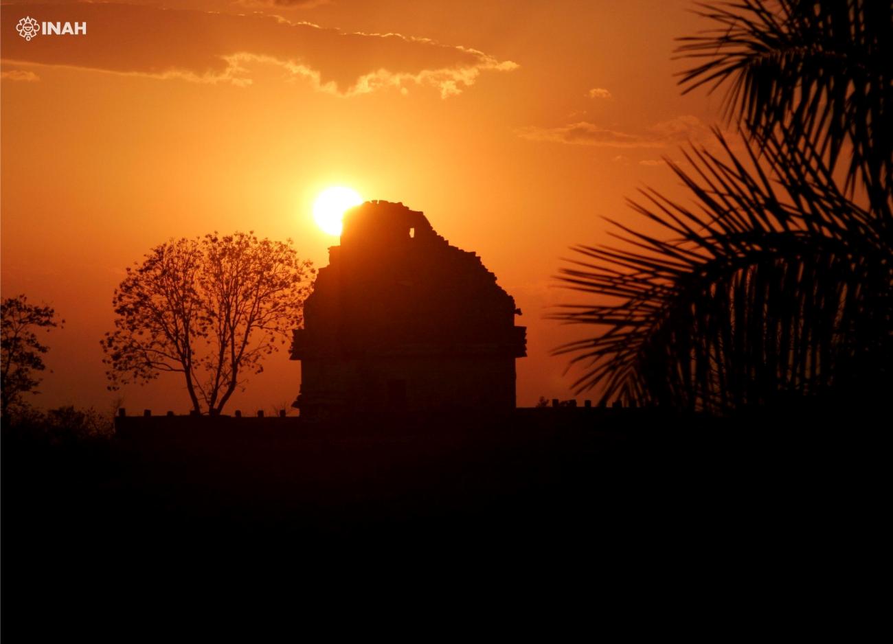
El Caracol is the rounded building commonly called the Observatory. Its circular form stands out from the rectangular platforms and temples around it. The structure’s windows and alignments have been linked to astronomical observations, including the movements of Venus and other celestial bodies.
Maya astronomers and calendrical specialists possessed sophisticated knowledge of repeating cycles. That knowledge was not isolated science in the modern academic sense. Sky observation helped organise ritual time, agricultural expectations, royal performance, and the interpretation of omens. Astronomy, mathematics, writing, and political authority were connected.
It is tempting to call El Caracol a modern observatory, but that word can imply a building used only for measurement. The monument likely had several roles, and the surviving structure has been rebuilt and interpreted through archaeological work. Its shape and alignments are meaningful evidence, not a complete instruction manual.
The city’s broader orientation also matters. Buildings, plazas, causeways, cenotes, and sightlines created a landscape in which movement and cosmology were linked. A visitor who rushes directly to El Castillo can miss how the city’s monuments create a sequence of spaces. If you have time, slow down between major buildings and notice changes in scale, elevation, enclosure, shade, and direction.
 El Caracol, the circular observatory building at Chichén Itzá, in its northern ceremonial group
The Sacred Cenote and pilgrimage
The Sacred Cenote lies north of the main plaza, connected to the ceremonial core by a raised causeway. It is not the swimming cenote visitors seek elsewhere in Yucatán. The water body was a ritual place, and archaeological investigation recovered offerings including ceramics, precious materials, and human remains.
Spanish colonial accounts described sacrifice at the cenote, but those accounts were written after conquest and must be read critically. Archaeology confirms that offerings were placed there and that some human remains are present. It does not justify every dramatic story repeated in popular tourism.
For the ancient city, the cenote’s importance was both local and regional. A place understood as sacred could draw pilgrims and offerings from beyond the immediate settlement. That religious authority could strengthen the city’s political position. A ruler who controlled access to a renowned sacred place could present the city as a centre of communication with powerful forces.
The cenote also makes the city’s geography visible. Chichén Itzá did not separate “nature” from “architecture” in the way many modern maps do. Water, stone, trees, roads, temples, and people formed one ritual landscape. The causeway was not only a convenient route. It connected distinct places through movement and ceremony.
Today the Sacred Cenote is viewed from a distance and is not a swimming stop. Do not compare it with recreational cenotes near Valladolid or Homún. Its role in the history of Chichén Itzá is religious, archaeological, and cultural, not a promise of a swim.
GuideThe Sacred Cenote of Chichén Itzá: History, Ritual and How to VisitA practical cultural guide to the Sacred Cenote of Chichén Itzá, including its Maya ritual importance, archaeological discoveries, human sacrifice evidence and how to include it in your visit.Open
Trade, households, and ordinary work
The monuments make rulers and gods easy to see, but most of the city’s history happened beyond the grand façades. Farmers produced maize and other crops under demanding seasonal conditions. Potters, stoneworkers, plasterers, painters, weavers, cooks, carriers, builders, and traders supported urban life. Families maintained houses, stored food, raised children, and negotiated obligations to powerful institutions.
Archaeologists study these less spectacular traces through ceramics, tools, animal remains, building patterns, soil, human remains, and the distribution of materials. A city cannot be sustained by temples alone. Its political power depended on a network of settlements and on people who could feed and supply a large population.
Craft production likely included ceramics, stone tools, shell and bone working, textiles, pigments, and prestige objects. Some goods moved long distances, while other everyday items were produced locally. The presence of imported or non-local materials does not mean every person had the same access to wealth. Ancient cities were socially unequal, and monumental abundance rested on unequal labour and resource distribution.
The city’s causeways, plazas, and water sources also organised movement. Some routes may have been used for processions, while others linked residential and ceremonial areas. Visitors today follow modern paths shaped by conservation and crowd management, not necessarily the exact routes of ancient residents.
Remembering ordinary work changes the way you look at the ruins. The polished stone you see represents quarrying, transport, cutting, carving, plastering, painting, repair, and maintenance. The empty plaza was once full of people. The city’s history is not only the story of famous rulers; it is also the story of the communities that made a famous city possible.
Why Chichén Itzá declined
“Why did Chichén Itzá fall?” sounds like it should have one answer. It does not. The city’s decline probably unfolded through overlapping changes in politics, trade, population, climate, conflict, and regional alliances.
Major monumental construction appears to have slowed after the thirteenth century. That does not prove that everyone left at once. Political authority can weaken while households remain, and sacred places can continue to matter after a ruling dynasty loses control. The archaeological record is a record of changing activity, not a video of one final day.
One factor may have been competition from other centres, especially the rise of Mayapán in the political landscape of northern Yucatán. Later Maya histories describe conflict involving powerful groups, but colonial-era accounts were written long after many events and combine history, genealogy, political memory, and narrative. They are valuable sources, not uncomplicated transcripts.
Environmental stress may also have mattered. Northern Yucatán communities depended on seasonal rainfall, agricultural knowledge, and stored resources. Drought or irregular rainfall could reduce harvests and intensify conflict, although climate evidence does not automatically establish a direct cause for every political change. Economic networks can also shift when ports, allies, or regional priorities change.
The city may have lost its ability to mobilise labour and resources at the same scale. Monument building, elite ceremony, military activity, and long-distance exchange require coordination. Once that coordination weakened, the urban centre could become less dominant even if its sacred places remained important.
Avoid the phrase “the Maya disappeared.” Maya peoples and languages continued, and millions of Maya people live across the region today. The history being discussed is the decline of Chichén Itzá as a particular political centre, not the disappearance of a civilisation or a living culture.
After political decline: a sacred place remains
Chichén Itzá did not become meaningless when its regional power changed. The Sacred Cenote retained religious importance, and the site remained part of the cultural landscape of Yucatán. Later Maya communities carried oral histories and relationships to ancient places even as Spanish colonisation imposed new political and religious systems.
During the colonial period, Spanish authorities tried to reshape indigenous religious life. Indigenous people continued to maintain cultural knowledge under difficult conditions, sometimes openly and sometimes through adaptation. The ancient city’s remains were not simply waiting for European “discovery”; local people knew the landscape and its stories.
European and North American explorers became increasingly interested in Maya ruins during the nineteenth century. Drawings, photographs, maps, collecting, excavation, and restoration brought global attention, but they also involved unequal power and the removal of objects from their original contexts. Modern archaeology has a responsibility to acknowledge that history rather than presenting exploration as a neutral adventure.
The formal archaeological work of the last century has transformed understanding of the city. Excavation revealed buildings, sculptures, inscriptions, ceramics, offerings, and construction phases. Conservation made the site accessible but also shaped what visitors see. Restored stone is not identical to untouched ancient fabric, and reconstructions always involve choices about evidence, stability, and public interpretation.
In 1988, UNESCO inscribed the Pre-Hispanic City of Chichén-Itzá as a World Heritage site under cultural criteria. The designation recognises the site’s architecture, historical influence, and importance for understanding the Maya-Toltec cultural synthesis. It also underlines the need for conservation in a place exposed to heavy visitation, tropical weather, erosion, and infrastructure pressure.
The Gran Museo and a better way to visit
The Gran Museo de Chichén Itzá adds useful context that the open-air ruins cannot provide. Museum displays can show small objects, excavation finds, models, and explanations of chronology, trade, social organisation, writing, astronomy, architecture, and the Cenote Sagrado. The museum is especially helpful if you want to understand the city as a whole rather than remember only its largest pyramid.
A good visit is not a race to photograph El Castillo. If you arrive with limited time, identify three questions before entering. For example: How did water shape the city? What changes between the southern and northern architectural groups? How did rulers use public space and imagery? These questions will make even a short visit more meaningful.
Go early if you want cooler conditions and a quieter first look. Chichén Itzá is a major attraction, and crowd levels vary by season, transport patterns, weather, and special events. Check current opening arrangements, ticket rules, access restrictions, and conservation notices with official sources before travelling. Do not assume an old blog’s hours or prices still apply.
The site is exposed and hot for much of the year. Bring water in a permitted container, sun protection, practical shoes, and enough time to walk between groups. Follow barriers and staff instructions. Do not climb closed monuments, touch carvings, buy objects presented as archaeological, or treat sacred places as props for jokes or stunts.
If you want an expert explanation of the historical sequence, a licensed guide can help you distinguish evidence from popular claims. Compare current Chichén Itzá tours on GetYourGuide or see Chichén Itzá options on Viator. A guided day trip from Mérida can be practical when you do not want to arrange transport, but an independent visit gives you more control over pace and time in the museum.
From Mérida, Valladolid, or an overnight stay?
Chichén Itzá is in Yucatán State, near the town of Pisté and the municipality of Tinum. It is an inland archaeological site, not a coastal destination. Mérida makes a workable base for a long day, while Valladolid is closer and can make an earlier arrival easier. The right choice depends on whether you value a simpler day, more time in the area, or a route that combines the ruins with cenotes and other inland places.
From Mérida, compare the total day rather than only the entrance journey. A tour may combine Chichén Itzá with a cenote, Izamal, or a regional meal, but combination days can feel compressed. A private driver or rental car offers more control, while public transport requires checking current schedules and allowing for less flexibility.
From Valladolid, Chichén Itzá can fit naturally into an eastern Yucatán itinerary. You can pair the visit with Valladolid’s colonial centre or a separate cenote day, but avoid stuffing every nearby attraction into one schedule. Heat, walking, and travel time are real limits.
If you prefer to sleep closer to the site, check current hotels near Chichén Itzá on Booking.com and compare nearby stays on Trip.com. Inventory changes, so verify the property’s exact location and current transport arrangements rather than relying on a listing title alone.
What the history should change in your visit
History should make the site more complex, not less accessible. You do not need specialist knowledge to appreciate Chichén Itzá. You only need to resist the idea that every building has one certain label and every dramatic story is fact.
Look at the city at several scales. At the largest scale, notice how plazas, causeways, temples, cenotes, and groups of buildings create an urban landscape. At the middle scale, compare masonry, decoration, columns, stairways, and building orientation. At the smallest scale, notice carved figures, offerings, masks, serpent forms, and signs of restoration.
Then ask who is missing from the postcard. Where would food have been prepared? Who carried stone? Who maintained plaster and roofs? Where did farmers, craft workers, children, traders, and pilgrims live? The surviving monuments answer some questions and leave others open. That uncertainty is part of honest history.
The old “rise and fall” formula can also be misleading. Chichén Itzá’s history was not a straight climb from primitive settlement to glorious city followed by total disappearance. It was a sequence of expansions, renovations, cultural negotiations, conflicts, continuities, and changes in regional power. Maya history continued around it and beyond it.
Frequently asked questions
Was Chichén Itzá built by the Maya or the Toltecs?
Chichén Itzá was a Maya city whose architecture and art show connections with central Mexico and other parts of Mesoamerica. The older story of a simple Toltec invasion is not accepted as a complete explanation. The evidence is better understood as cultural interaction, migration, political strategy, and shared or adapted ideas, with the exact balance still debated.
How old is Chichén Itzá?
Occupation began many centuries before the most famous buildings. Dates vary depending on which sector and evidence are being discussed. The city’s history extends across roughly a millennium, with important early development, a major period of regional power around the Terminal Classic and early Postclassic transition, and later decline.
Did Chichén Itzá have human sacrifice?
Archaeological evidence from the Sacred Cenote includes human remains and offerings, and sacrifice formed part of some ancient Maya and wider Mesoamerican ritual practices. Popular claims often go further than the evidence allows. It is better to speak carefully about specific findings and avoid presenting sensational stories as a complete account of ancient religion.
Why is El Castillo associated with the equinox?
The pyramid’s geometry and the seasonal position of the sun can produce a serpent-like light-and-shadow effect along the northern balustrade. The building also has wider calendrical and ritual significance. The modern equinox spectacle should not be treated as proof that ancient builders intended precisely the same event in the same form.
Did the Maya abandon Chichén Itzá because of drought?
Climate stress may have contributed to food shortages, migration, or political instability, but drought alone does not explain the city’s history. Competition, changing trade networks, internal conflict, and the ability of rulers to organise labour and resources also mattered. Archaeologists continue to refine the evidence.
Can I climb El Castillo?
Access rules change, and the main monuments are generally protected from climbing. Follow the current instructions from site staff and respect barriers. The best photographs and the most useful historical experience do not require climbing a protected monument.
Is Chichén Itzá still important to Maya people?
Yes. It is an archaeological and heritage site within a living Maya region. The ancient city is also important to researchers, local communities, cultural institutions, and visitors, but tourism should not reduce Maya history to a vanished civilisation. Use the correct name, listen to local interpretation, and treat the site as a place of cultural significance rather than an abandoned stage.
A final way to read the city
Stand in front of El Castillo, then look beyond it. Chichén Itzá’s power was never contained in one pyramid. It came from water, food, movement, skilled work, public ritual, political relationships, sacred geography, and the ability to bring different traditions into a new local form. Its decline was not the end of Maya history, and its modern fame is not the whole of its ancient story.
Visit with enough time to see at least one earlier southern complex, the Great Ball Court, the Temple of the Warriors, El Caracol, and the Sacred Cenote from the permitted viewing area. Read the museum displays if they are open, check current site rules, and leave room for uncertainty. That approach turns a famous photograph into a real historical place.
Chichén Itzá is worth visiting not because it offers one simple answer about the Maya past, but because its stones keep asking better questions.